
Advisories, Watches and Warnings
 How to obtain information about weather and road conditions
Pay attention to the news. Local radio and television stations provide up-to-date weather information. Investing in a National Oceanic and Atmospheric Administration (NOAA) Weather Radio is another way to receive weather and other emergency alerts, and you can program them so that you receive only the alerts for your county or specific counties.
![]() Subscribe to RSS feed of watches, warnings and advisories in Iowa issued by the National Weather Service.
Subscribe to RSS feed of watches, warnings and advisories in Iowa issued by the National Weather Service.
![]() The Iowa Department of Transportation offers real-time information on current road conditions on their website or by calling 5-1-1.
The Iowa Department of Transportation offers real-time information on current road conditions on their website or by calling 5-1-1.
Types of Advisories, Watches and Warnings
The information provided here is courtesy of the National Weather Service (NWS). These are hazards that regularly affect the state of Iowa.
For additional information on weather watches and warnings, visit your local NWS website.
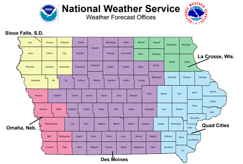
Click on a link or the map below to visit the NWS forecast office websites.
Adair, Adams, Appanoose, Audubon, Black Hawk, Boone, Bremer, Butler, Calhoun, Carroll, Cass, Cerro Gordo, Clarke, Crawford, Dallas, Davis, Decatur, Emmet, Franklin, Greene, Grundy, Guthrie, Hamilton, Hancock, Hardin, Humboldt, Jasper, Kossuth, Lucas, Madison, Mahaska, Marion, Marshall, Monroe, Palo Alto, Pocahontas, Polk, Poweshiek, Ringgold, Sac, Story, Tama, Taylor, Union, Wapello, Warren, Wayne, Webster, Winnebago, Worth, Wright (51) |
|
Benton, Buchanan, Cedar, Clinton, Delaware, Des Moines, Dubuque, Henry, Iowa, Jackson, Jefferson, Johnson, Jones, Keokuk, Lee, Linn, Louisa, Muscatine, Scott, Van Buren, Washington (21) |
|
Buena Vista, Cherokee, Clay, Dickinson, Ida, Lyon, O'Brien, Osceola, Plymouth, Sioux, Woodbury (11) |
|
Allamakee, Chickasaw, Clayton, Fayette, Floyd, Howard, Mitchell, Winneshiek (8) |
|
Fremont, Harrison, Mills, Monona, Montgomery, Page, Pottawattamie, Shelby (8) |
National Weather Service Products
Click on the tabs for more information.
- A flood watch is issued when current and developing conditions are such that there is a threat of flooding, but the occurrence is neither certain nor imminent.
- A flood warning is issued when there is flooding along larger streams causing a serious threat to life or property. A flood warning will usually contain river stage (level) forecasts.
- A flash flood watch indicates that flash flooding is possible in and close to the watch area. Those in the affected area are urged to be ready to take quick action if a flash flood warning is issued or flooding is observed.
- A flash flood warning signifies a dangerous situation where rapid flooding of small rivers, streams, creeks, or urban areas is imminent or already occurring.
- A heat advisory is issued within 12 hours of the onset of the following conditions: heat index of at least 105�F but less than 115�F for less than three hours per day, or nighttime lows above 80�F for two consecutive days.
- A tornado watch means that conditions are favorable for the development of tornadoes in and close to the watch area.
- A tornado warning means that a tornado is indicated by radar or has been sighted by storm spotters. The warning will include where the tornado is and what towns will be in its path.
- A wind advisory is issued with sustained winds from 25 to 39 mph and/or gusts to 57 mph.
- A severe thunderstorm watch means that conditions are favorable for the development of severe thunderstorms in and close to the watch area.
- A severe thunderstorm warning is issued when a thunderstorm produces hail 3/4 of an inch or larger in diameter and/or winds which equal or exceed 58 mph. Severe thunderstorms can result in the loss of life and/or property. Information in this warning includes: where the storm is, what towns will be affected, and the primary threat associated with the storm.
- A winter storm watch indicates that severe winter weather may affect your area.
- A winter storm warning indicates that severe winter weather conditions are definitely on the way or are already here.
- A blizzard warning means that large amounts of falling or blowing snow and sustained winds of at least 35 miles per hour are expected for several hours.
- A blowing snow advisory is issued when wind-driven snow reduces surface visibility, possibly hampering travel.
- A wind chill advisory is issued when the wind chill could be life threatening if action is not taken.
- A wind chill warning is issued when the wind chill is life threatening.
- A freezing rain/drizzle advisory is issued when freezing rain or freezing drizzle is forecast but a significant accumulation is not expected. However, even small amounts of freezing rain or freezing drizzle may cause significant travel problems.